Recently, Assam Chief Minister Himanta Biswa Sarma gave a stern message to Bangladesh over its recent rhetoric regarding India’s Siliguri Corridor, also known as the ‘Chicken’s Neck’. Reminding Bangladesh of its own geographical vulnerabilities, Sarma said that Dhaka should not forget that it has two Chicken Necks.
“We have one Chicken’s Neck. But Bangladesh has two Chicken Necks. If Bangladesh attacks our Chicken’s Neck, we will attack both the Chicken Necks of Bangladesh. The one in Meghalaya connecting Chittagong Port in Bangladesh is even thinner than India’s Chicken’s Neck and is located just a stone’s throw away,” Sarma told reporters during a press briefing.
Sarma’s statement came after Muhammad Yunus, the head of Bangladesh’s interim government, referred to the northeastern states of India during his March visit to Beijing. Yunus had urged China to strengthen its economic influence in Bangladesh. Making a pitch to China, Yunus said that India’s northeastern states are landlocked and described Bangladesh as the “only guardian of the ocean” in the region.
Himanta Biswa Sarma’s Statement:
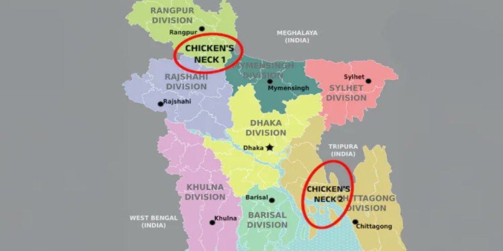
What Are the Two Chicken Necks of Bangladesh Referred to by the Assam Chief Minister?
1. The Chittagong Corridor:
This is a narrow strip of land in southeastern Bangladesh that connects the country’s main territory to Chittagong, its largest port city. This corridor spans approximately 30 kilometers, between Sabroom in India’s Tripura and Mirsharai Upazila in Bangladesh.
This corridor plays a crucial role in Bangladesh’s logistics and economy. If blocked, it would cut off Chittagong from the rest of Bangladesh. Notably, Chittagong Port handles more than 90 per cent of Bangladesh’s foreign trade.
For context, this is also the shortest land route from India’s landlocked state of Tripura to the sea. It is also the narrowest point between the core territory of Bangladesh and its eastern region, which includes Chittagong.
“The shortest distance between the landlocked Indian state of Tripura and the sea is 30 km. Of course, it cuts across Bangladesh. It’s also the narrowest distance from the larger mass of Bangladesh and its eastern division of Chittagong,” said Yusuf Unjhawala, an adjunct scholar, in a post on X.
2. The Rangpur Corridor:
This corridor lies between South West Garo Hills in Meghalaya and South Dinajpur in West Bengal, with Bangladesh’s Rangpur Division located in between. The strip stretches around 90 kilometers and serves as another narrow connection between different administrative regions of Bangladesh.
“Their ‘Chicken’s Neck’ near Meghalaya to Chittagong Port is much smaller than ours and can be choked by throwing even a ring,” Sarma had said.
China’s Strategic Interest In Lalmonirhat Airfield in Bangladesh:
Recent reports suggest that China may gain access to a strategic airbase in Lalmonirhat, Bangladesh. This would allow it to monitor Indian military movements through the Siliguri Corridor — a critical and vulnerable link connecting India’s northeast to the rest of the country.
Lalmonirhat is located about 100 km from the Siliguri Corridor and just over 20 km from the Indian border. Any airbase in this area could pose a strategic threat to India’s connectivity with its northeastern states.

Leave a comment